


Methods
This article combines satellite data with official Ukrainian records, independent environmental assessments and the published literature. Satellite imagery was used to map changes in air pollution, surface water, burned areas and fires in protected areas between 2021 and 2024. These results were then compared with documented damage records. The maps show broad spatial patterns and were not validated on the ground.
War's Forgotten Front
Wars and their impacts are usually measured in common metrics.[1] Combattant deaths,[2] displaced persons,[3] or infrastructure destruction cost.4 These dominate the public debate whilst addressing conflicts, because they can be counted, compared across conflicts, and converted into policy: a death toll, a refugee figure, a reconstruction bill. Environmental damage is far harder to reduce to comparable figures. It unfolds over decades, crosses borders, and rarely produces a number anyone can put in a headline.
In that view, the Russian invasion of Ukraine's overall picture has largely been understood through this same lens. Ukraine has indeed generated staggering figures across every category, from millions of people forced out of their homes,3 to reconstruction bills amounting into hundreds of billions of dollars.[4]
But as awareness grows about the damage inflicted on lands, rivers, and air, omitting the environmental impact of war is no longer defensible.
The damage is real, and does not represent a secondary footnote to the humanitarian crisis that began in 2022: it feeds directly into it.[5]
Attacks on Kharkiv's water supply and treatment systems (including documented strikes on water technicians) have directly threatened safe drinking water for the city's residents.[6]
The widespread use of land mines, leaking and degrading soil structure, also makes the agricultural lands unusable.[7]
Strikes on industrial facilities in the east push sulphur dioxide and heavy metals into river systems that provide drinking water to tens of millions of people.[8]
These are not just ecological concerns, as they largely contribute to the catastrophic public health and food security issues that will most likely outlast the conflict by years, if not decades.
Environmental damage is also set apart by its scale and its underlying dynamics.
The impacts are not randomly distributed, but rather follow the geography of the war: across the east and south, where coal plants, metallurgical facilities, dense river networks, and front lines converge.[9]
Burning fuel depots release pollutants that settle on farmland.[10] Contaminated soils wash into rivers.[11] Rivers carry that contamination toward the Black Sea.[12] Landmines lock up agricultural territory for a generation.7 These systems are connected, and damage in one feeds damage in another in ways that are genuinely difficult to trace, let alone repair.5
Some of it can be quantified. Ukraine's Ministry of Environmental Protection estimated roughly $56.4 billion in environmental damages as of June 2023, most likely to increase with three more years of combat since then.[13] About 29% of the country's territory needs a mine and ordnance survey.[14] Over 1.2 million hectares of protected areas have been “bombed, polluted, burned, or otherwise affected by military maneuvers” according to UNDP,[15] while nearly a million hectares of forest burned in 2024 - more than in the entire EU that year.[16]
Still, a significant part of it can not be properly measured, precisely because of the conflict itself. Mines, booby traps, and explosive remnants of war have made large stretches of the front line too dangerous for researchers to enter; a 2024 CEOBS briefing notes this leaves much of the damage unassessed.[17] The inaccessible areas include occupied zones, front lines, mined territories, and collapsed industrial sites. Satellite data bridges part of the gap - for nitrogen dioxide, fire hotspots, water losses - but not all of it.[18] A satellite confirms a fire happened, but can not tell what is now sitting in the soil beneath it.
All these gaps matter far beyond science. Damage that goes unrecorded can not be claimed in reparations, factored into reconstruction costs, nor support a legal case. An incomplete record is also a convenient one for anyone invested in disputing the scale of what happened.
What follows maps the damage across air, water, soil, and biodiversity, using satellite data, Ukrainian monitoring platforms, and independent environmental assessments. The Nova Kakhovka dam collapse gets its own section: one infrastructure failure that reshaped an entire region's hydrology in hours and hit the north-western Black Sea within days.[19]
Ukraine Before 2022
2.1 Ukraine's ecological overview
Ukraine covers less than 6% of Europe's landmass and hosts roughly 35% of its biodiversity, equivalent to more than 70,000 species, many of them rare, relict or endemic.[20] The variety of ecosystems accounts for much of this. The Carpathian forests cover the west, with ancient beech stands and alpine meadows. The Polissya wetlands stretch across the north, extending into Poland and Belarus. The central and eastern parts of the country contain what remains of the Pontic steppe, a grassland system that has been vanishing across Europe for centuries. The southern coast opens onto the Black Sea and the Sea of Azov, while the Dnieper floodplain runs through the country from north to south.20
These landscapes do not stop at the border. The Danube Delta is shared with Romania and Moldova. The Carpathians cross into four neighbouring countries. The Dniester basin extends into Moldova. Therefore when ecosystems are damaged inside Ukraine, the loss is structurally European, not Ukrainian alone.[21]
Agriculture adds another dimension. Ukraine holds roughly 25% of the world's chernozem, the deep, organic-rich black soil that makes it one of the most productive agricultural regions on the planet.[22] According to the Food and Agriculture Organization, Ukraine holds roughly 25% of the world's chernozem, the deep, organic-rich black soil that makes it one of the most productive agricultural regions on the planet. Arable land covers 54% of the national territory.22 Soil quality is not a technical detail here. Chernozem holds water and nutrients far better than ordinary soil, which is what allows Ukrainian yields without the fertiliser inputs most of Europe depends on. It also takes centuries to form and cannot be restored on any useful timescale - once compacted, cratered, or contaminated, the loss is effectively permanent.
2.2 The Soviet industrial legacy
Yet Ukraine was also, well before 2022, an heavily industrialised landscape. Decades of Soviet-era heavy industrialisation concentrated chemical plants, coal mines, metallurgical complexes, oil refineries and energy infrastructure in the east and south. According to the OSCE's 2017 assessment, the Donetsk and Luhansk regions alone hosted some 4,500 potentially environmentally hazardous enterprises before the conflict even began.[23] Many were already ageing and operating below modern environmental standards.[24]
This industrial geography explains the spatial logic of what came later. The heaviest fighting settled over the Donbas and the southern industrial corridor - exactly where the chemical plants, coal mines, and metallurgical complexes were. Wartime pollution therefore did not spread evenly across Ukraine. It concentrated on sites that were already contaminated, and released, in weeks, hazards that decades of Soviet industry had accumulated and contained.
Nuclear infrastructure overlays all of this. Ukraine operates four nuclear power plants and still manages the Chernobyl exclusion zone. The zone is, in itself, a strange ecological case. After the 1986 disaster, the absence of human activity allowed it gradually to become a sanctuary for wildlife. The UN Environment Programme describes it as the third-largest nature reserve in mainland Europe, hosting wolves, bears, lynx and Przewalski's horses.[25] A six-year UNEP and GEF project launched in 2015 had been formalising the reserve and managing carbon stocks and biodiversity inside it.25 So the actual state of Chernobyl before February 2022 was not an empty, dead landscape. It was a site of active monitoring, hosting scientific research, biodiversity programmes and long-term ecological work.
The Donbas mines tell another version of the same story. After 2014, Ukraine lost control over a large share of the Donbas coal industry, and many of the abandoned mines began to flood. Power cuts disabled drainage systems and groundwater rose through the shafts. According to UWEC, when groundwater fills mine voids it leaches heavy metals and salts from rocks, eventually reaching rivers and the Sea of Azov.[26] By 2017 the OSCE was already documenting more than 35 mines in the process of flooding or already flooded.23 By 2022 the number had climbed further.26
The Yunkom mine in Yenakiieve is the most worrying case. An underground nuclear explosion was carried out there in 1979 for industrial purposes. The post-2018 flooding of Yunkom raised serious concerns about radioactive contamination spreading through groundwater far beyond Donbas.26 This is exactly the type of slow-moving, long-tail pollution that does not produce a satellite image but durably reshapes the environmental baseline of an entire region.
2.3 The 2014 precedent
The war that started in Donbas in 2014, eight years before the full-scale invasion, had already produced documented environmental damage: industrial disruptions, water infrastructure failures, mine flooding, contaminated rivers, biodiversity pressure inside protected areas.23 26 The OSCE Project Co-ordinator in Ukraine, working with the Ukrainian Ministry of Ecology and Natural Resources, conducted a full environmental assessment of eastern Ukraine in 2017 that covered soils, surface waters, industrial risks, mine flooding, forest resources, protected areas and biodiversity.23 That such an assessment was already necessary in 2017 says much about where the region was heading.
The war since 2022 did not create environmental fragility from scratch. It accelerated the collapse of a system that was already under documented stress, in a country whose ecological vulnerabilities had been mapped by international institutions for years. The 2014 precedent also explains why some pollution sources active nowadays, especially groundwater contamination from flooded Donbas mines, cannot be cleanly separated from pre-2022 dynamics. That does not reduce the responsibility for the damage caused after the full-scale invasion. However, it does complicate future work on attribution, liability claims and reconstruction planning.
Ukraine entered 2022 as a country of exceptional ecological value whose eastern regions were already industrially degraded, with environmental warnings accumulating for nearly a decade. The invasion made both conditions worse simultaneously.
The First Months of the war
Before any long-term assessment could begin, a series of distinct shocks had shaped the early environmental footprint of the conflict, each with its own geography, mechanism and aftermath. Four of them deserve close attention: the occupation of a nuclear site, the destruction of major industrial complexes, the first satellite signals of polluted air, and a hit to agriculture and food security. Together they outline a pattern that would repeat throughout the rest of the war: damage moving faster than the institutions designed to record it.
3.1 Chernobyl occupation (February–April 2022)
Troops crossed the border from Belarus on 24 February 2022 and seized the exclusion zone of Chernobyl the same day, as part of the broader offensive on Kyiv. They held the site for five weeks, withdrawing only on 31 March, as part of the wider retreat from northern Ukraine.[27] The choice of Chernobyl as a strategic objective was loaded with symbolism, but the environmental consequences reached far beyond the seizure itself.
Sensors installed by Ukraine's Chernobyl EcoCenter registered the impact as it happened. Beginning after 9 p.m. on 24 February (when Russian forces arrived from Belarus) the network recorded sharp jumps in radiation along major roads and near the reactor facilities. Early on 25 February the network stopped reporting, and it stayed dark until 1 March.[28]
Russian convoys drove directly through the Red Forest, the most heavily contaminated zone inside the exclusion area, kicking up clouds of radioactive dust.[29] More damaging still, troops dug trenches and built fortifications inside the forest itself, often without any protective equipment.[30] Energoatom, Ukraine's state nuclear company, warned that the greatest danger came from inhaling radioactive dust the soldiers themselves had disturbed.30 Several Russian soldiers were later reported to have shown signs of radiation sickness, though neither Russia nor Belarus officially confirmed those accounts.29
The monitoring blackout compounded the danger. The International Atomic Energy Agency lost remote data transmission from its Chernobyl system during the occupation and could not access the plant for weeks.29 For a facility that requires constant management of radioactive materials, an absence of oversight is a major safety problem on its own. Russian control of the site blocked the relief crews, leaving local plant workers on duty for up to three weeks at a time instead of their normal rotation, under prolonged radiation exposure.29
By the time Russian forces withdrew at the end of March 2022, much of the site's scientific infrastructure (monitoring equipment, laboratories, data records) had been stolen or destroyed. Ukrainian authorities reported that more than 1,000 computers were looted or damaged, along with vehicles, radiation dosimeters, and scientific equipment, with total losses exceeding €50 million.27 A European Union-funded laboratory for radioactive waste management, worth more than €6 million, was destroyed, and samples of radionuclides were removed from the site.[31] Ukrainian officials said decades of accumulated documents and archives discarded.31
3.2 Industrial explosions and acute toxic releases
If Chernobyl symbolises the nuclear dimension of the first months, Azovstal symbolises the industrial one. During the siege of Mariupol in the spring of 2022, the Azovstal plant, a Soviet-era metallurgical complex covering around 11 km² of the city, was subjected to sustained bombardment.32 33 For more than two months, a Soviet-era metallurgical complex covering around 11 km² of the city was subjected to near-daily bombardment.[32] [33] Azovstal was one of Ukraine's largest steel producers, accounting for nearly 4% of national exports and 0.5% of GDP before the war.33 It also carried decades of accumulated environmental liabilities: stored chemicals, heavy metals, slag and industrial waste built up since the plant was established in 1933.33
The bombing destroyed ground-level infrastructure along with chemical storage facilities and waste-disposal sites. Toxic substances leaked into the groundwater and toward the Sea of Azov.32 The Mariupol City Council warned in May 2022 that damage to facilities holding tens of thousands of tonnes of hydrogen sulphide solution at Azovstal could devastate marine life in the Azov, with possible knock-on effects reaching the Black and Mediterranean Seas.[34] CEOBS later documented 87 separate instances of direct damage to the site and found, using synthetic aperture radar analysis, that at least 57% of built structures had been affected.33 Because Mariupol remains under occupation, no independent field assessment of the contamination has been possible since.33
Azovstal was not the only major industrial site hit in this way. The neighbouring Ilyich Iron and Steel Works in Mariupol, the largest sinter plant in Europe and a facility employing more than 14,000 people before the war, suffered comparable damage.33 Both plants have been left to decay under occupation, and CEOBS analysis of satellite imagery in 2023 suggested that much of the heavy machinery was being dismantled and sold for scrap.33
The broader pattern matters. Azovstal and Ilyich are the most visible cases, but they are far from the only ones. Fuel depots were hit across several regions in the first weeks, producing large fires and black smoke columns clearly visible in satellite images. Multiple chemical plants were struck, releasing ammonia, nitric acid and other industrial substances into the local environment.24 These were point-source events, but their consequences spread outward at once: pollution entered air, soil and groundwater simultaneously, and through wind and water flows moved far beyond the strike zone itself. Foreign Policy magazine put it bluntly in mid-2022, describing destroyed wastewater treatment plants spewing raw sewage into rivers while industrial sites leaked heavy metals and chemicals into the surrounding environment.32
3.3 First satellite evidence
While the physical damage was unfolding on the ground, the war’s atmospheric signature was already being read from orbit. Within weeks of the invasion, researchers were using the Copernicus Sentinel-5P satellite and its TROPOMI instrument to track changes in air composition over Ukraine.[35] TROPOMI measures the atmospheric column of several pollutants, including nitrogen dioxide (NO₂), sulphur dioxide (SO₂) and carbon monoxide (CO), and covers Ukrainian territory in full, even where ground-based monitoring has collapsed.
The signal turned out to be more complicated than a simple rise in pollution. Over major cities, NO₂ concentrations actually dropped. In Kyiv, the April 2022 tropospheric NO₂ monthly average was nearly 60% lower than in 2019 and 2021, as normal traffic, industry and economic life collapsed under the invasion.35 Across Ukraine's major urban and industrial areas, second-quarter NO₂ levels fell 15 to 46% below the 2018–2021 reference period - well outside the normal year-to-year variability of 5 to 15%.35 These numbers could easily be read as a sign of environmental recovery. They are nothing of the sort: they reflect the collapse of civilian activity, not cleaner air.
At the same time, short-term episodes linked to missile and drone strikes pushed near-surface pollutants up by 100 to 400%, with extreme cases above 1000%. SO₂ rose in regions still relying on dirtier fuels.[36] The most striking finding came from fire activity: in 2022, 66% of Ukraine's total burned area lay within 30 km of the front line, and the proportion rising to nearly 80% in 2023.36 Peak fire activity was accompanied by NO₂, CO and aerosol concentrations that exceeded the historical daily maxima recorded between 2018 and 2021.36
Two things matter here. The damage was measurable from the very early weeks, not only with hindsight. Therefore, the international community had access to objective satellite-based evidence of war-related environmental damage within the first months of the invasion, even when ground access was already impossible. This period also set the methodological precedent for the rest of the war. When the ground is inaccessible, satellites become the primary witness, with all the strengths and blind spots that this implies. The counterintuitive finding that war can lower NO₂ in cities while raising it locally near front lines and industrial sites is exactly the kind of result only satellite data can produce. It also marks the limit of that data: the most useful measurement tool is also the one that cannot tell what is really in the soil.
3.4 Agricultural land and food security
The alarm over the agricultural consequences was raised internationally within weeks, because Ukraine is central to the global grain and oilseed trade. In 2021, Ukraine and Russia were, together or individually, among the world's top exporters of wheat, maize, rapeseed, sunflower seed, and sunflower oil.[37] The FAO warned that a sudden, prolonged cut in their exports would fall hardest on food-importing nations - many already classified as Least Developed Countries or Low-Income Food-Deficit Countries dependent on Ukrainian and Russian supplies - and projected that the global number of undernourished people could rise by 8 to 13 million in 2022/2023.[38]
Black Sea ports were closed or blockaded, halting the maritime exports that carried the bulk of Ukrainian grain. International food commodity prices spiked in March 2022.[39] Agricultural land in the south and east, some of the most productive chernozem territory in Europe, fell under occupation.[40] Landmines and unexploded ordnance were laid across farmland on a scale that eventually made Ukraine the most mined country in the world, locking large areas out of use.[41] Heavy military equipment compacted and damaged soil structure, alongside the cratering and trenching that scarred the land.39 Fertiliser supply chains broke down, leaving Ukrainian farmers without the inputs needed to maintain yields on the land that could still be cultivated.40
Water added another layer to the agricultural crisis, and the North Crimean Canal is the clearest example of how entangled these dynamics became. Built in the Soviet era to bring Dnieper water to Crimea, the canal had been blocked by Ukraine after the 2014 annexation. Crimea's irrigated agricultural land shrank dramatically as a result, from 130,000 hectares in 2013 to just 14,000 hectares by 2017, and the peninsula began to experience accelerated soil salinisation.[42] Russian forces seized and reopened the canal in the first days of the 2022 invasion, restoring water flow to the peninsula.41 A year later, after the Kakhovka dam was destroyed in June 2023, the mouth of the canal quickly dried up again.41
The downstream consequences of these hydrological shifts were enormous. Southern Ukraine's irrigation system, which depended on the Kakhovka reservoir, included more than 12,000 km of canals serving up to 500,000 hectares of cropland across Kherson, Zaporizhzhia and Dnipropetrovsk oblasts.41 These regions receive only 100 to 120 mm of rain during the summer growing season, insufficient for most crops without irrigation.41 The Ukrainian Grain Council estimated that the dam's destruction could reduce national grain exports by around 14% in the months that followed.41
The food-security alarm that the FAO sounded in March 2022 (when its Food Price Index leapt 12.6 percent in a month to an all-time high)[43] was not a discrete event. It opened a long stretch of pressure on Ukrainian and global agriculture that satellite imagery, port closures, mine surveys, and crop-yield estimates would track for years.
4. The Anatomy of Destruction
4.1 Air: combustion, fires and atmospheric pollution
CEOBS has documented the environmental risks posed by fossil fuel infrastructure in Ukraine since Russia’s invasion in February 2022, including oil storage fires, refinery damage, pipeline disruptions, and strikes on fuel depots. In the short term, such incidents may cause air pollution; over the longer term, spilled fuel and firewater runoff may contaminate land and water systems.[44] Air pollutants may also travel beyond their point of origin, depending on wind, precipitation, atmospheric stability and topography, so the environmental effects of a fire or explosion may extend well beyond the immediate impact area.[45]
Nitrogen dioxide (NO₂) is mainly produced when fuel is burned at high temperatures. Its major sources include road transport, thermal power plants, industrial combustion, fires and military machinery. This makes NO₂ a useful proxy for combustion-related pollution. It is also relevant from a public-health perspective. The European Environment Agency estimates that reducing air pollution to World Health Organization guideline levels could have prevented 34,000 deaths attributable to NO₂ exposure in the EU in 2023.[46]
We used Copernicus Sentinel-5P data to map NO₂ concentrations over Ukraine between 2022 and 2024 (Figure 1). The indicator does not capture street-level exposure. Instead, it measures the atmospheric column of NO₂ observed from space, making it more suitable for identifying broad spatial patterns than for assessing local human exposure. This distinction is particularly important in a conflict setting, where ground-based monitoring may be absent, disrupted or inaccessible in areas affected by hostilities.
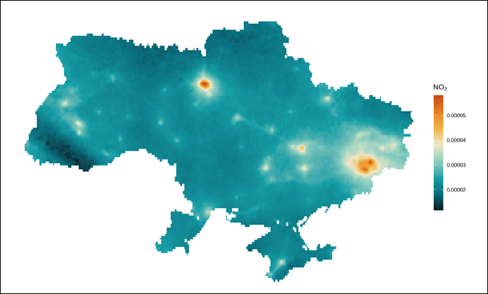
Figure 1. NO₂ concentration over Ukraine, 2022–2024.
Source: Copernicus Sentinel-5P, processed by the author.
The NO₂ map should not be interpreted as direct proof of a single emission source. Higher concentrations may reflect the combined presence of urban transport, industrial activity, thermal power generation, fires and war-related destruction. Conversely, lower values in some areas may reflect reduced industrial activity, depopulation, transport disruption or limitations of satellite observation rather than environmental recovery.
Sulphur dioxide (SO₂) provides a complementary signal. SO₂ is associated with the burning of sulphur-containing fuels, coal combustion, oil refining, industrial processes and fires at fuel or chemical facilities. Copernicus describes Sentinel-5P as a mission designed to monitor atmospheric gases including NO₂ and SO₂, which are relevant for air quality, health and climate monitoring.[47]
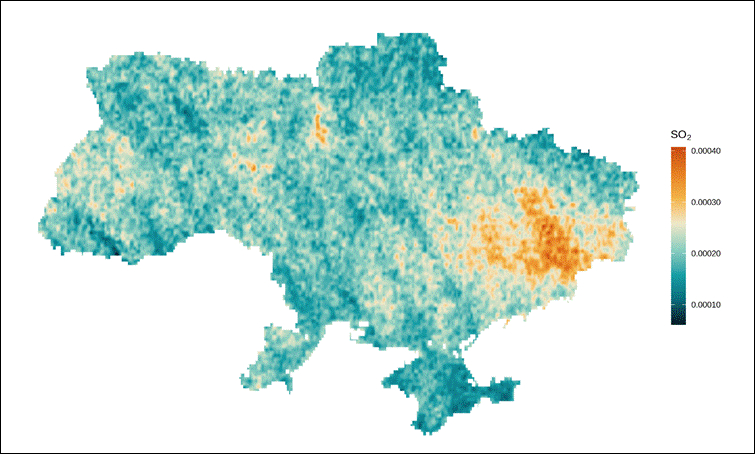
Figure 2. SO₂ concentration over Ukraine, 2022–2024.
Source: Copernicus Sentinel-5P, processed by the author
The highest SO₂ concentrations appear in eastern Ukraine (Figure 2). This pattern coincides with the region’s concentration of coal-fired power generation, metallurgy, mining and heavy industry, as well as areas exposed to intense military activity. CEOBS has documented attacks on fossil fuel infrastructure in Ukraine, including oil depots where strikes caused large fires and short-term air pollution.44
Taken together, the NO₂ and SO₂ maps indicate a conflict-shaped atmospheric landscape. Some emissions may decline where civilian industry, transport and economic activity have collapsed. Other emissions may arise or intensify where fuel infrastructure, industrial sites, fires and military activity overlap. The maps therefore function less as a direct attribution tool than as spatial evidence of atmospheric disturbance under wartime conditions.
4.2 Water: infrastructure destruction, river contamination and marine degradation
Ukraine’s water infrastructure was already vulnerable before the full-scale invasion. A 2025 study in Scientific Reports analysed 168 wastewater samples from 10 Ukrainian cities and found that wastewater from Kharkiv and Lviv contained heavy-metal concentrations 100 to 1,000 times above safe limits.[48] The same study notes that Ukraine has around 2,500 water supply and sewerage service companies and reports that more than 50% of water infrastructure was already deteriorated, rising above 70% in some cases. After February 2022, the water and wastewater sector suffered about $4 billion in direct damage, while total financial losses were estimated at $11.6 billion.
Wartime damage therefore struck a system that was already fragile. Shelling, occupation and infrastructure damage placed additional pressure on wastewater treatment plants, pumping stations, pipelines, canals, irrigation systems and other hydraulic infrastructure. When these systems are damaged, untreated sewage, industrial wastewater, oil products, heavy metals, sediments and agricultural chemicals can enter river networks and travel downstream.
EcoZagroza, the official environmental monitoring platform of Ukraine’s Ministry of Environmental Protection and Natural Resources, records aquatic resources as a separate category of wartime environmental damage. According to its dashboard, 216 documented incidents relate to aquatic resources, with estimated damage of about 123.05 billion UAH (roughly US$3 billion).[49] These figures do not capture the full ecological impact, but they provide an official baseline, establishing damage to water resources as a distinct and measurable category of wartime loss.
Ukraine’s major river systems connect industrial areas, agricultural land, cities, wetlands and coastal ecosystems. UWEC notes that around 70% of Ukraine’s river flow originates in neighbouring countries. It also states that the Dnieper and Siverskyi Donets basins supply water to around three-quarters of Ukraine’s population. The Dnieper alone provides water to 30 million people, 50 large cities and industrial centres, about 10,000 enterprises, 2,200 rural settlements, more than 1,000 public utilities, 50 large irrigation systems and four nuclear power plants.[50]
This river-basin structure makes water pollution both a downstream and transboundary risk. Pollution entering the Dnieper, Dniester, Siverskyi Donets or coastal systems can cross administrative borders and eventually reach the Black Sea and the Sea of Azov. The marine pathway includes river-borne sewage, fuel residues, heavy metals, suspended sediments and nutrient flows from damaged infrastructure, ports, coastal cities and industrial sites. These pollutants may contribute to eutrophication, algal blooms, oxygen depletion and habitat degradation.[51]
Recent hydropolitical research also treats water as a strategic asset, because control over dams, canals and reservoirs can shape access to drinking water, irrigation and energy. A 2025 GeoJournal article analyses the Dnieper River basin using remote-sensing methods such as NDWI and NDVI, linking the North Crimean Canal and the Kakhovka dam to broader struggles over territory, infrastructure and resource control.[52]
4.3 The Nova Kakhovka Dam Collapse: Hydrological and Ecological Consequences
The destruction of water systems can therefore be understood not simply as pollution affecting individual rivers or reservoirs, but as a broader disruption of infrastructure, river basins and marine ecosystems. These interconnected systems sustain drinking water supplies, agriculture, wetlands, fisheries and coastal biodiversity, meaning that damage to one component can generate wider environmental consequences across the entire water network.[53]
The destruction produced two connected effects. Downstream, floodwaters swept through settlements, infrastructure, soils and riparian ecosystems. Upstream, the reservoir contracted rapidly, exposing the former lakebed and disrupting aquatic habitats. UNEP concluded that much of the damage caused by the breach is likely irreversible and that some consequences may affect ecosystems and human health over the long term.
Figure 3 compares surface water conditions before and after the destruction of the dam using the Normalized Difference Water Index (NDWI). Red areas indicate water loss, while blue areas indicate new or increased water presence. The strongest water-loss signal appears at the former Kakhovka Reservoir, marking the breach as a major disruption of the Dnipro River’s regulated flow.
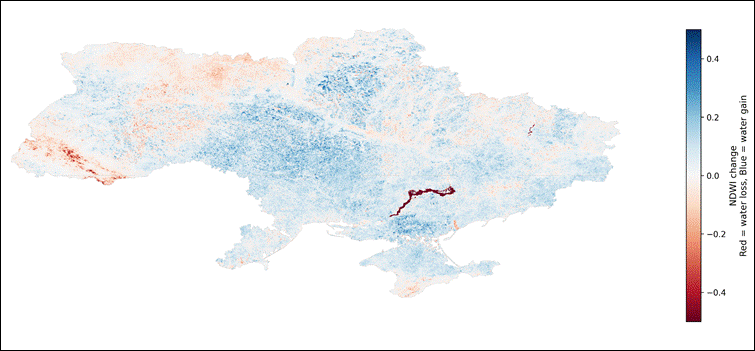
Figure 3. Surface water change in Ukraine, 2021–2024.
Red indicates water loss; blue indicates new or increased water presence. Source: Copernicus Sentinel-2, NDWI calculation, processed by the author.
The measurable scale of the collapse confirms the magnitude of the disruption. OCHA reported that the volume of water in the Kakhovka Reservoir fell by about 80% after the dam’s destruction.[54] EcoZagroza, estimated that water volume fell by 14.395 billion m³, while environmental damage linked to the Kakhovka disaster was estimated at 77.8 billion UAH (roughly US$1.8 billion). The same dashboard reported 1,144 flooded settlements and 63,447 hectares of flooded forest.49
The downstream and marine effects extended beyond the reservoir. UNEP identifies chemical contamination, debris, waste, sediment movement and ecological damage among the main environmental impact categories of the breach.53 A 2025 study in Communications Earth & Environment found that the dam breach affected more than 50% of the north-western Black Sea area, with chlorophyll-a and suspended sediment concentrations rising to more than 50 times ambient levels. The same study observed elevated nitrate and phosphate concentrations near the Odesa coast and linked the event to severe algal blooms that began within one week and lasted about 20 days.[55]
The destruction of the Kakhovka dam has also been discussed as a potential case of ecocide in legal and political debates.[56] Ecocide refers to severe environmental harm that is widespread, long-term, or both, although its status as an international crime remains contested.56 Used analytically, the term helps to describe the simultaneous disruption of water supply, agriculture, fisheries, forests, wetlands, sediments, coastal ecosystems and marine biodiversity. It should not, however, replace the empirical description of the event: the dam breach created observable hydrological change, documented infrastructure losses, downstream contamination risks and measurable effects in the north-western Black Sea.
The long-term effects remain uncertain. Exposed sediments could contain heavy metals, nutrients and other pollutants accumulated over decades. Flooded areas are likely to experience soil contamination, vegetation loss and ecosystem restructuring. Marine impacts might also persist through altered nutrient flows, sediment transport and coastal habitat stress. The destruction of the Kakhovka dam should therefore be treated not simply as past infrastructure damage, but as an ongoing environmental process requiring long-term monitoring.
4.4 Soil and land: burned areas, landmines and degraded agricultural landscapes
War affects agricultural and natural landscapes through physical disturbance, restricted access and changes in land management. These effects may appear in different forms, including damaged vegetation, exposed soil, burned areas and delayed recovery. Where fighting, occupation or restricted movement prevail, regular land management and field inspection also become more difficult, making the condition of farmland, forests, riverbanks and protected areas harder to assess directly.
Burned land serves here as one spatial indicator of landscape disturbance. Fire leaves a visible surface signal that can be detected from satellite observations and compared across space and time. In agricultural areas, affected surfaces may reflect changes in field conditions or land-use activity, although burned-area data alone cannot establish that such changes were caused by the war. In forests, wetlands, steppe areas and protected landscapes, burned areas help identify where vegetation cover has been affected. Burned-area mapping therefore offers a useful window onto one part of the wider environmental impact, though it does not capture all forms of land degradation.
Figure 4 maps burned areas across Ukraine during 2022–2024 using NASA Terra and Aqua burned-area observations processed by the author.
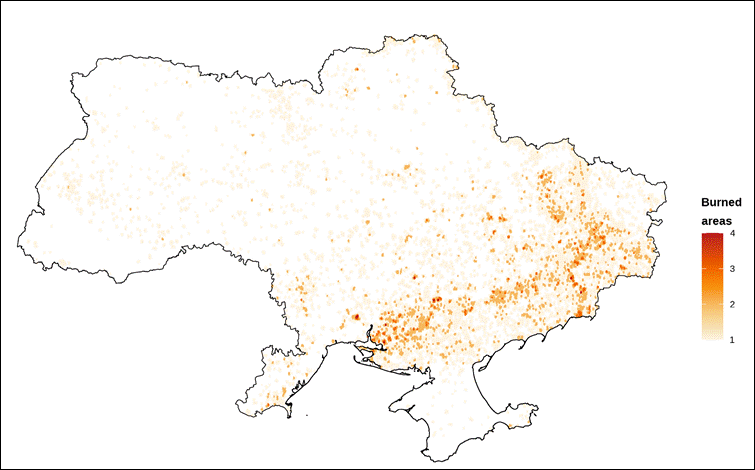
Figure 4. Burned areas in Ukraine, 2022–2024.
Source: NASA Terra/Aqua burned-area observations, processed by the author.
This pattern is consistent with independent satellite-based reporting on fires in Ukraine during 2024. According to the European Commission’s Joint Research Centre, about 965,000 hectares—nearly one million hectares—burned in Ukraine in 2024, more than twice the burned area recorded across the entire European Union during the same period.[57] Reuters reported a similar estimate, noting nearly 9,000 fires in 2024 and stating that about one-third of the burned area affected cropland.[58]
Landmines and unexploded ordnance create a separate but connected land-access problem. ACAPS reports that the Government of Ukraine estimated about 174,000 km², nearly 29% of the country’s territory, as requiring survey for possible contamination by mines and explosive remnants of war.[59] This figure should not be interpreted as confirmed mined territory. It refers to land requiring survey or clearance, meaning that agricultural land, forests, roads and riverbanks may remain unsafe or unusable until they have been inspected. Figure 5 shows the yearly dynamics of survey and clearance activities. This indicator matters because mine contamination is not only an environmental problem, but a practical barrier to agricultural recovery, forest management, infrastructure repair and biodiversity monitoring.
Figure 5. Surveyed and cleared land in Ukraine by year.
Source: compiled by the author from ACAPS and Ukrainian mine-action reporting.
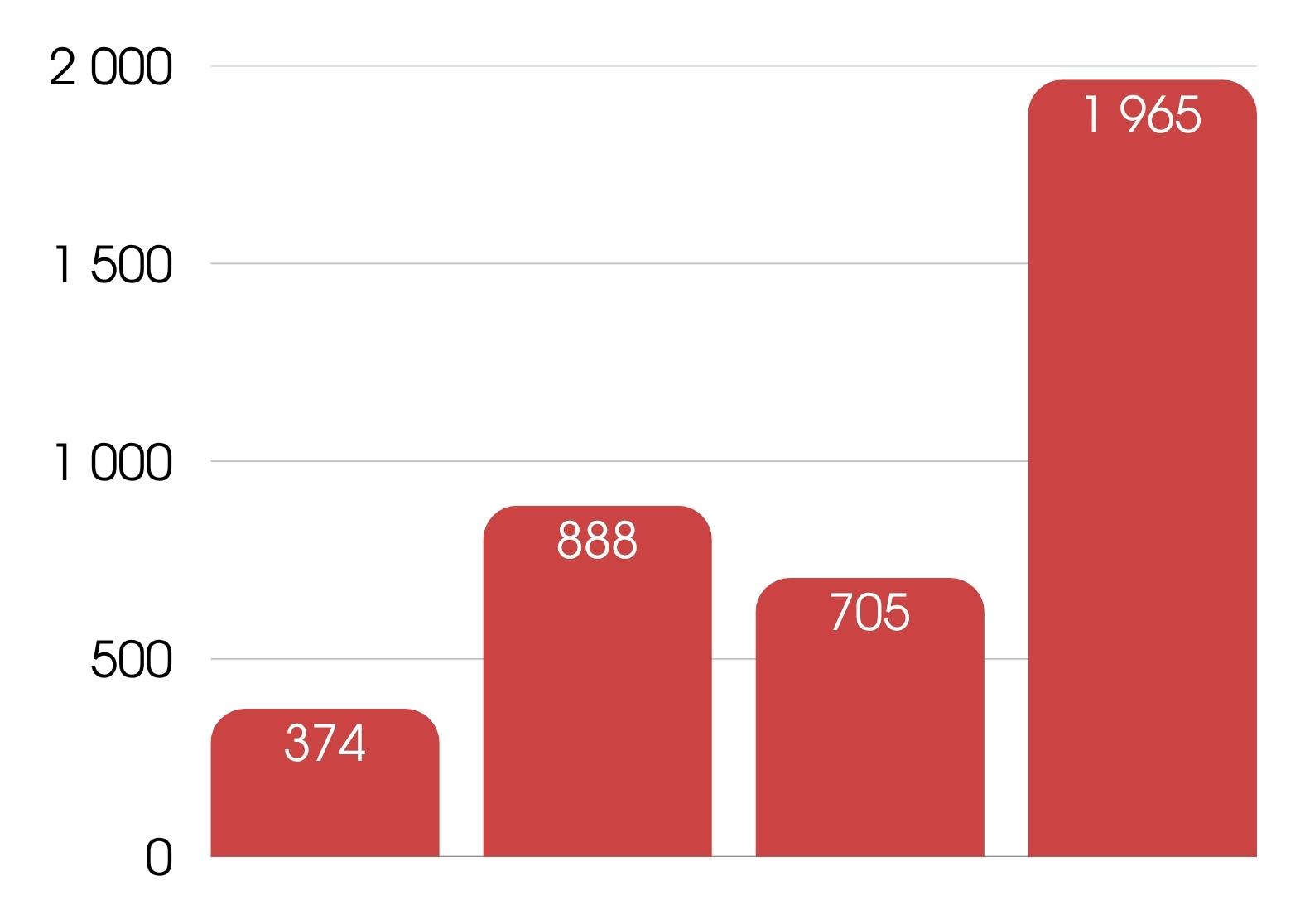
The comparison between burned areas and mine-risk territory reveals two distinct forms of land degradation during 2022–2024. Fire damages the ecological condition of land directly, while mine contamination restricts access, management and recovery. Together, these indicators show that wartime land degradation extends beyond battlefield destruction to burned agricultural areas, inaccessible mine-risk zones, degraded vegetation cover and delayed restoration of rural and protected landscapes.
4.5 Biodiversity: protected areas, fire disturbance and ecosystem fragmentation
Ukraine occupies an outsized place in Europe’s ecological landscape. WWF Central and Eastern Europe states that the country provides habitat for about 35% of Europe’s biodiversity and some 70,000 plant and animal species, including rare, relict and endemic ones.[60] This makes the condition of Ukrainian ecosystems relevant not only to national environmental recovery, but also to European biodiversity conservation as a whole.
Their legal status does not shield protected areas from the effects of war. Shelling, fires, occupation, mining, pollution and restricted access can all degrade the ecological functions these areas are meant to sustain. As a result, the impacts can extend across the wider conservation network rather than remaining confined to individual sites.
Figure 6 shows the overlap between protected areas and active fire detections during 2022–2024. The analysis combines NASA FIRMS active fire detections with the World Database on Protected Areas (WDPA) for Ukraine. Fire hotspot activity overlapped with roughly 23,400 km² of protected-area surface, equivalent to 22.7% of the total WDPA protected-area surface included in the analysis. [61]
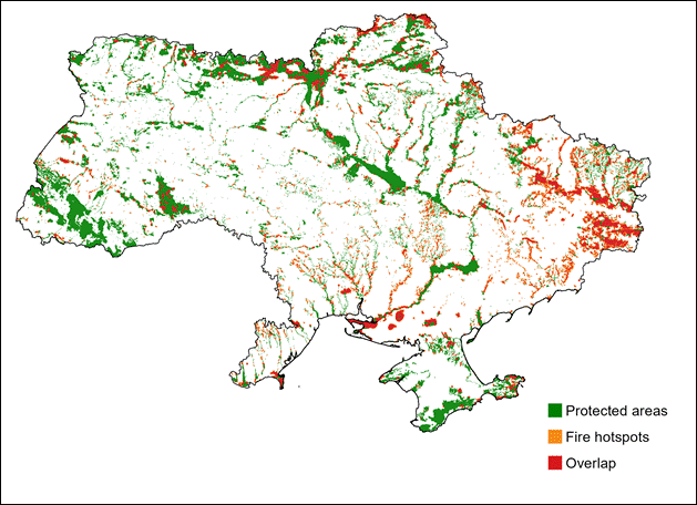
Figure 6. Fire hotspot activity inside protected areas in Ukraine, 2022–2024.
Source: NASA FIRMS and World Database on Protected Areas, compiled by the author.
This figure should not be read as meaning that 22.7% of protected areas burned completely. It shows that active fire detections occurred within protected landscapes across the area mapped. Such exposure matters ecologically because fire can strip vegetation cover, destroy nesting sites, fragment habitats, increase erosion and reduce ecosystems’ capacity to recover.
The concentration of fire hotspots in eastern, southern and northern parts of Ukraine also points to the overlap between protected landscapes and conflict pressures. CEOBS notes that the war has caused widespread and locally severe damage to some of Ukraine’s most ecologically important areas, and that landmines and explosive ordnance may restrict access and management for decades to come.[62] This limits field surveys, fire control, habitat restoration and species monitoring across occupied, mined or frontline territories.
Biodiversity loss in Ukraine therefore extends well beyond direct species mortality. It also includes damage to protected areas, fire-disturbed habitats, forest degradation, restricted scientific access and the long-term fragmentation of conservation landscapes.
5. Data Limitations
War, occupation and restricted access also limit environmental measurement. Field surveys are often delayed, incomplete or replaced by remote and indirect assessment methods. The result is a persistent gap between when environmental damage occurs and when it can be verified through field-based evidence.
Several documentation systems attempt to reduce this gap. EcoZagroza, the official platform of Ukraine’s Ministry of Environmental Protection and Natural Resources, records wartime environmental threats with geographic references and categorises damage across air, aquatic resources, land resources and protected areas. Its dashboard records documented incidents and monetary estimates for several categories of environmental damage.[63]
EcoDozor provides another layer of documentation. Developed by the Zoï Environment Network with support from the OSCE Project Co-ordinator in Ukraine and UNEP, the platform is a map-based database of conflict-related environmental incidents drawn from open-source and media reports. By 31 May 2022, it had recorded around 4,800 incidents. However, many reported environmental effects could not be verified on site, meaning that the database documents reported incidents rather than providing complete field-confirmed assessments.[64]
CEOBS offers a complementary form of evidence through its thematic environmental briefings. Its work on fossil fuel infrastructure, for instance, documents the risks arising when oil depots, refineries and pipelines are struck.[65] Such cases show why environmental damage cannot always be assessed immediately. A fuel depot fire may be visible from satellite imagery, but its full implications for air quality, soil, groundwater or human health require subsequent field sampling and laboratory analysis.
The Nova Kakhovka dam breach demonstrates the same problem on a larger scale. UNEP’s rapid environmental assessment concluded that much of the damage caused by the breach is likely irreversible and may affect ecosystems and human health over the long term.[66] Yet the assessment gap remains substantial: some impacts were immediately visible, including flooding, water loss, sediment movement and damage to settlements. Other effects, such as heavy metals in exposed sediments, groundwater contamination, ecosystem restructuring and impacts on the Black Sea, require sustained monitoring that active conflict makes difficult to carry out.
Remote sensing is therefore necessary but limited. Satellite data can track changes in water surfaces, burned areas, active fire detections, forest loss and atmospheric pollution, helping to document environmental change where ground access is restricted. What it cannot do without ground-based validation is measure heavy metals in agricultural soils, detect mine contamination, determine the precise cause of every fire or gauge the full health burden of air pollution.
This uncertainty matters for accountability. Environmental claims require evidence showing where damage occurred, how severe it was, which systems were affected and what recovery may cost. Where evidence is missing, damage risks being underestimated, excluded from compensation claims or left out of reconstruction planning altogether. The data challenge is therefore not only technical: it shapes legal responsibility, restoration priorities and the eventual assessment of the full scale of wartime environmental harm.
Environmental accountability in Ukraine depends on whether ecological damage can be documented with sufficient precision to support restoration, compensation and legal assessment. The available evidence remains uneven. Satellite data can track changes in NO₂ and SO₂ concentrations, burned areas, active fire detections, protected-area exposure and water-surface change, while official monitoring platforms and independent environmental organisations provide complementary records of wartime damage. No single source, however, can capture the full scale or consequences of that damage. 63 However, none of these sources is sufficient alone.
This limitation is not only technical. Satellite imagery can show that water disappeared from the Kakhovka Reservoir, but it cannot determine the chemical composition of exposed sediments without field sampling. Active fire detections can reveal fire activity within protected landscapes, but they cannot measure species loss. Official damage registers can quantify reported incidents, yet occupied, mined and frontline areas may remain under-documented because of access constraints.
For accountability, these gaps are significant. Environmental harm that cannot be adequately documented risks being underestimated in reconstruction planning or excluded from compensation claims altogether. This is especially problematic for slow or delayed effects, including groundwater contamination, heavy metals in soil, ecosystem fragmentation, species loss and long-term damage to protected landscapes.
Ukraine’s environmental damage should thus be understood as both an environmental and an evidentiary problem. The immediate destruction is already visible in satellite data, official registers and field reports. Its full scale, however, will depend on long-term monitoring, access to currently unreachable territories, laboratory verification and the preservation of evidence for future environmental liability.